North America's relatively calm summer weather ended last week when a powerful derecho swept across the Midwest — from South Dakota to Ohio — on August 10, 2020, and a rare firenado struck Northern California on August 15, 2020. If you are like most people, you have probably never heard of either of the rare natural phenomena. Here is a brief explanation of the incredible extreme weather events.
Derecho

Derecho (which means "straight ahead" in Spanish) is defined by the National Oceanic and Atmospheric Administration (NOAA) as "a widespread, long-lived windstorm that is associated with a band of rapidly moving showers or thunderstorms." Though the storms are a global phenomenon, most derechos have been recorded across the central and eastern United States. They are, however, very infrequent, occurring an average of just one or two times a year during the spring and summer months.
The windstorms are caused by what scientists call a downburst. When moist air from a thunderstorm encounters the surrounding drier air, it causes the water to evaporate and cool down the air. The colder, denser air rapidly sinks to the ground and creates strong winds associated with derechos. However, not all windstorms can be classified as such. For a derecho to occur, the wind must move at speeds of at least 58 miles an hour and travel over 240 miles. The August 10, 2020, Midwest derecho had winds of up to 112 miles an hour and traveled an astounding 770 miles in just 14 hours!

How are derechos different from tornados?
Derechos, which span at least 50 miles (80 km) in width, are similar to tornadoes except for one aspect — they produce walls of straight-line strong winds instead of the swirling gusts associated with tornadoes. The rare storms can be as destructive as tornadoes, albeit in a slightly different way. While a tornado's rotating winds cause debris to scatter in various directions, the derecho's straight-line winds leave behind pockets of massive devastation next to areas that remain virtually untouched.

The August 10, 2020, derecho, described by Northern Illinois University meteorology professor Victor Gensini as one of the worst weather events of 2020, was particularly damaging. The powerful windstorm, which tore across the US corn belt — from Nebraska to Iowa to Wisconsin to Illinois — left over 1.5 million people without power and damaged, or destroyed, 10 million acres, or 43 percent, of Iowa’s corn and soybean crop. It also uprooted thousands of trees and caused damage to hundreds of structures.
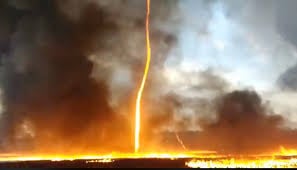
Fire Tornadoes
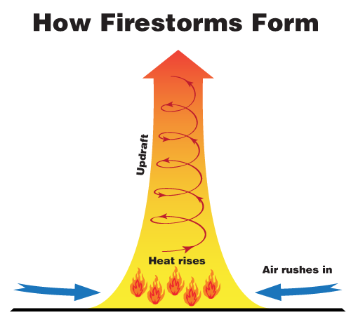
Also called fire whirls or firenados, the natural phenomena occur when the ground-level air, superheated by wildfire flames, rises. The void left behind is instantly filled by cold air. As more and more air gets pulled in, it begins to rotate, creating a tornado-shaped spiral of flames as it comes in contact with the fire. In addition to toppling trees and blowing off rooftops, the powerful “tornadoes” also lift burning embers into the atmosphere. The winds carry the embers to surrounding areas, resulting in new fires that are miles away from the center. The floating sparks also enable the wildfires to jump rivers, highways, and fire breaks.
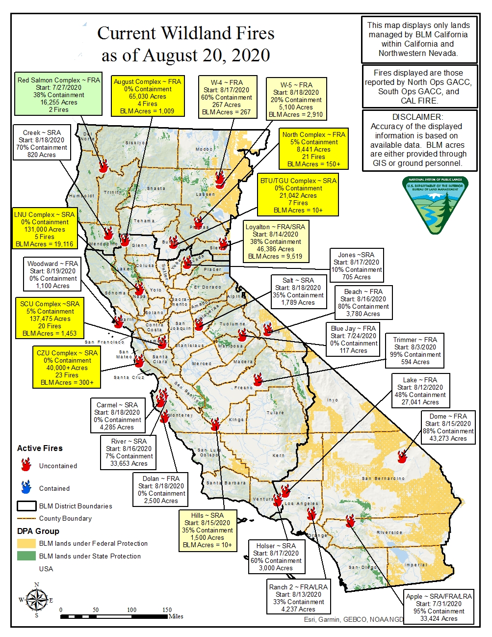
The August 15, 2020, firenado was caused by the Loyalton Fire, which has been burning near Loyalton, California, since August 14, 2020. The massive fire, which is only 35 percent contained as of August 20, 2020, has scorched 43,000 acres and is one of hundreds of wildfires currently burning across California. Most of the blazes were ignited over the weekend by an extreme heatwave accompanied by humid air that caused a potent mix of triple-digit temperatures and thunderstorms that flashed over 10,000 lightning strikes across the state in 72 hours!
The firenado and lightning were capped off with a new world temperature record. On August 16, 2020, Death Valley in southeastern California's Mojave Desert recorded a searing 130 degrees Fahrenheit. If verified, it could set a new global record for the highest temperature ever observed during August and rank among the top three highest temperatures on Earth. Given that the only two higher measurements —134 degrees Fahrenheit in Death Valley in 1913 and 131 degrees Fahrenheit in Kebili, Tunisia, in 1931 — were never confirmed by experts, some believe Death Valley could even take the top spot for this unwanted honor.
Resources: CNN.com, watchers.news, the guardian.com, NOAA.gov